

Madrid Subway Off-Line

Madrid Subway Off-Line açıklaması
The application is intended for quick and easy calculation of routes between two Madrid Subway stations without internet connection.
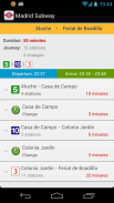
We will also have the chance to see the itinerary to make and its details. We can find the nearby stations to our position and, using Google Maps, guide us to them.
In future updates can save favorite routes, see google maps and viewing stations itineraries in the subway map and more...
Included:
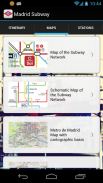
- New maps of Madrid subway 2013.
- All stations on Off-Line mode.
- Fast location and easy route calculation.
- Complete itinerary information, duration of journey and transfers to be performed.
</div> <div jsname="WJz9Hc" style="display:none">Uygulama internet bağlantısı olmadan iki Madrid Metro istasyonları arasında yollarının hızlı ve kolay bir hesaplama için tasarlanmıştır.
Ayrıca yapmak için güzergah ve ayrıntılarını görmek için şansına sahip olacak. Biz pozisyona yakın istasyonlarını bulmak ve, Google Maps kullanarak, onları bize rehberlik eder.
Gelecekteki güncellemeler metro harita ve daha fazla Google Maps ve izleme istasyonları güzergahlar görmek, sevdiğiniz yolları kaydedebilirsiniz ...
Dahil:
- Madrid metro 2013 Yeni haritalar.
- Off-Line modu Tüm istasyonlar.
- Hızlı konumu ve kolay rota hesaplama.
- Komple güzergah bilgileri, yolculuk ve yapılacak transferlerin süresi.</div> <div class="show-more-end">


